Featured

Using the Biodiversity Project in the future

I thoroughly enjoyed working on the Biodiversity in Pennsylvania project hosted by iNaturalist. Along with sharing the project with my family and bystanders I shared this with my coworkers. The rangers were helpful identifying and finding places to photograph observations. One ranger helped me to find an app, PictureThis, to help me with primary identifications. Towards the end of my project I shared the app and the project with a coworkers that are in charge of the volunteer program and the interpretive education program.

My intention was to see if we would be able to use this project at the park to help our own initiatives, including recording invasive species for management and removal and educating the public about our own biodiversity. We discussed using this for volunteers on our property and possibly doing a ranger guided hike and providing stops for observations. We also thought this could be used with our interpretive programs with students using our own tablets. Groups of students can log observations and learn about species that we have on property.

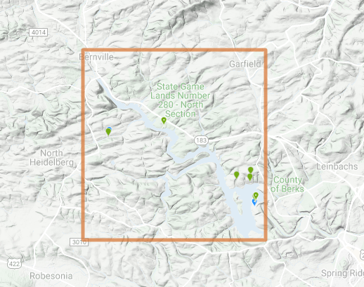
In our discussions found one area that could be improved. We wish there was a way that our boundaries could be added to the map that iNaturalist uses. When searching by location it is easy to search by town or by park boundaries such as state parks and larger preserves. Our park is posted as a large block that is loosely centered on the lake. It does not remain within our boundaries and the park is further subdivided into management zones for our natural resource management. We would like to be able to upload our own maps to use as a layer within the iNaturalist site for use with iMapInvasive or with the Biodiversity of Pennsylvania Project.
Personally, I plan on continuing my work with the project. It is fun and I would like to see how the data changes seasonally. I want to delve more deeply into the invasive species that are in iMapInvasives and possibly do research with the data. I have two family members that only just became aware of my project and want to join in. Maybe we will make this a family project.

The data is able to be used for multiple projects, research for an individual project, adding as a project for a park or a conservation group and for family fun.

I am concluding the blog portion of the project for now. Looking back over the project there are a few things I would add to the iNatualist site that would improve other projects. Based on the meeting with my coworkers, I would allow parks to upload maps or allow participants to outline and area using mapping tools for study areas. I think this would help meet conservation groups objectives for monitoring and increasing biodiversity within a specific area. I also think this would allow researchers to study different areas for comparison. Being able to change the study area to a particular size or location would allow for equal areas to be compared. Improving the export function would also make statistical and geographical analysis easier. The site currently only allows data to be exported in .csv format. This is somewhat limiting and adds several steps when manipulating the data for further analysis.

The second addition I would make is to allow people to create groups. A group of friends or a family could set a their own group. This would allow classes, clubs or other groups to go out and collect data for comparison. Challenges could be set and statistics could be gathered. The information can still be sent to the larger project, but the individual groups can maintain their own information as well.

Overall, I think this was a fun project and the longer I participated in it, the more applications I could see with the project and the data. I plan on following up with the larger project and also to get my family members involved. We may start a friendly competition and see how much we can document. I think this project can be used by every age and by different groups. It is easy to understand and to manage and it is fun. The site statistics are interesting and can be used for study purposes. I would like to see more citizen science projects like this.
Featured

Interactions with others.

Bad weather and recovery from a surgery have kept me inside for the most of this week. I decided to help other fellow citizen scientist. An important aspect of iNaturalist is relating to others and helping to ID species. When pictures are uploaded the community needs others to agree or disagree with the identification. The more that people have agreed or validated an identification, the higher the grade. There are three stages, unknown, casual and research grade. I took advantage of the poor weather to look at some other observations and see if I could identify or agree with others.

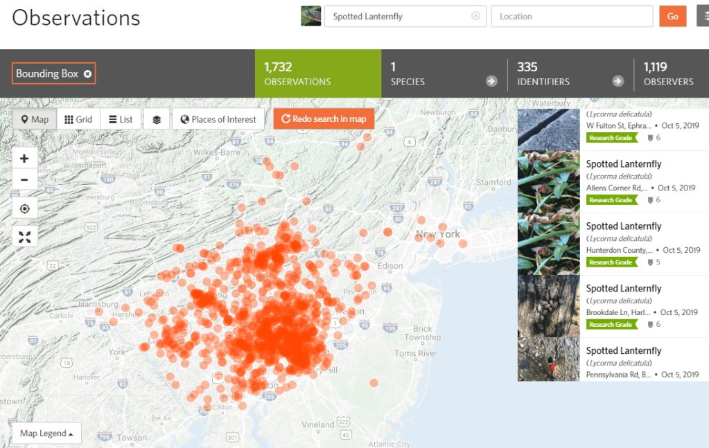
I am only beginning to be confident in some of my identifications, but there are several that I have made and I felt sure I would be able to locate those. It is easiest to search by species, but after looking at a number of people sharing the Spotted Lanternfly I decided to look at other observations near my home. I was able to agree with a large number of identifications, especially insects and mammals. Plants identification was a little harder and I did not know any fungi that I felt confident in agreeing or disagreeing with others identification.

It was fun to look at all of the observations that were so close to my home. It really does show how much biodiversity can be found in a small area. I would like to look at this more in the spring when I think more plant species and fish will begin to be posted.

Featured

iMapInvasives

I was doing research for another class on my local watershed and I came across another citizen science project. Pennsylvania iMapInvasives program is designed to help natural resource professionals by providing an online platform to share invasive species sighing and management efforts as well as offering training resources. Data collection is very important to control and eradicate invasive species, but developing a community for support and education is an important step in that process. The PA iMapInvasive program was launched in 2013 and is managed by the Pennsylvania Natural Heritage Program. There are three ways to to record information. There is an iMap Mobile app or a by using a smartphone or tablet to log into a browser to log into iMapInvasive.org, The final way is by the same app I have been using, iNaturalist . Arizona, New York, Oregon, Pennsylvania and Saskatchewan all have an iMapinvasive project already set up. Under projects, log in and chose the appropriate iMapInvasive project. Observations can be added for the biodiversity project and for recording invasive species.

Invasives Near You: Mapping Your Local Natural Area. A YouTube Video posted by paimapInvasive.org

Featured

Sharing with others

I have enjoyed taking observations and have made it a part of my life. I have taken a few day trips to Reading, Philadelphia and walks on my local trails. It has been fun sharing my project with family and friends but also other people I have encountered. I was taking a photo of a tree in Philadelphia when I was asked why I was taking a picture of weeds. I was able to share what the Biodiversity project is and also a little about invasive species. that ‘weed’ I was taking a photo of was Ivy. I was able to explain why Ivy is a problem in areas and how it compares to other invasive species.

The people wanted to take their own pictures so I showed them where the app was and they wanted to download it for themselves. In recording biodiversity, noting areas where invasive species are found can be important as well.

My family have also joined in my project. My younger daughter takes photos on her phone. She does not have the app and she uploads the pictures from Google Photos to the iNaturalist site from her Chromebook. She is able to type in the location and edit the time to when she took the picture. She has a smaller area to observe but she is also starting to notice more things to take pictures of and she is beginning to identify more on her own.

Featured

Picture this

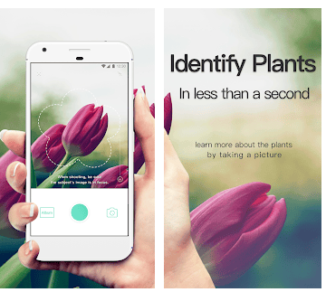
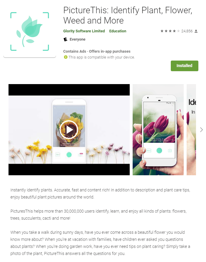
I found that I needed help in identifying several observations. My pictures either weren’t clear enough or were too similar to other plants. Many of my observations were being kept at the unidentified level and I wanted to find a way to improve my observations. I downloaded an app from the play store called PictureThis. It was recommended by another ranger at the park and we spent an hour or so taking pictures using it to determine this would help us.

It uses your phones camera. The ‘flower’ is the the area where you center your observation as close as possible. That is the area that will be scanned for matching. That itself took a little bit of practice to get clear pictures to show up in that area. It did help to confirm other suggestion son iNaturalist. I used a free trial with it and then I had an offer for 19.99 for the year. I was able to use this to confirm my questionable observations from iNaturalist and with my friend we used the free trials. I do think that if I continue the project in the future the 19.99 for a year may be a good investment. I like it as a supplement, but it is still easiest to identify observations in the iNaturalist app itself.

Featured

First impressions

Observations can be added by the website or by the iNaturalist app. I think the app might work best in my situation. I work at Blue Marsh Lake in Pennsylvania. I am able to record observations at different times. I have free time before and after work that I might be able to record neighborhood data. At work I occasionally go into the field and I may be able to record observations then. I plan on using my camera phone to upload photos and locations. The app does not take a lot of space and seems fairly easy to understand.

The first thing that is needed is to connect to the project you are working on. It seems like it is possible to work on multiple projects at a time, but for now I am only working on one. There is a tab that allows you to add an observation by either taking a photo, choosing an image on your phone, choosing a recorded sound from your phone or recording a new sound. I will be not be recording any sounds and will be either taking photos or uploading photos.

The details tab allows the observer to record notes, post the current time or edit it to a previous time, post the current location and note whether the observation is captive or cultivated. You are able to view suggestions from the app of what the observation might be, typically they list the top 10 that are visually similar. The app also will not if the species has been recorded in the area, that was helpful on a few instances trying to name the species.

After posting they activity log will record when others view your observation and confirm your initial identification . If more than 2 or 3 ID with the same species, then your identification gets raised to research grade. Other users are also able to comment and I have had a few share their own pictures of a species in response to mine.

Featured

Biodiversity of Pennsylvania

I chose Biodiversity of Pennsylvania as a project I wanted to contribute to. The loss of biodiversity has been a concern of the environmental movement for a considerable amount of time. Typically the oceans and tropical areas have been studied. These are ‘hot spots’ and are places of high concentrations of biodiversity. I agree they should be protected. Pennsylvania has had a substantial loss of biodiversity as well, especially since the arrival of the first Europeans (Kirkland et. al 1992). Plants have been studied in Pennsylvania for over 200 years and we have a record due to several historical collections. Biodiversity is often thought of as an indicator of an area’s environmental health. It can also be important for choosing an area to protect. An study can be undertaken to give weight to biodiversity indicators and also to ecological processes. This becomes important to consider which plot of land to save and how we can maximize our efforts and funds to best serve biodiversity conservation efforts (Eiswerth 2001).

The Biodiversity of Pennsylvania project is part of the umbrella project Biodiversity of the 50 states. The creator goes by the screen name, zoology123. He states that the reason for this project is he found it to be “outrageous that almost 43 of the 50 states didn’t have a biodiversity project.” on June 4, 2018 he created the project “Biodiversity of the United States, by State.” This project is for all 50 states and 16 territories in the United States. There are over 16 million observations by 475,000 people.

The Biodiversity of Pennsylvania Group has 33 members in it. A person just needs to register and be able to post photos or observations that have the location of Pennsylvania. There are no other qualifications based on education or standing.

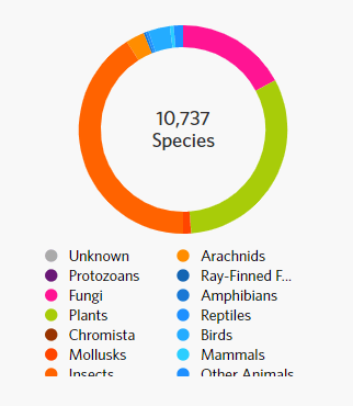
The Pennsylvania Diversity project has over 424, 000 observations of over 10,000 unique species. Of those species identified 41% were insects and 31.55 were plants. Mammals only made up . 58% of the total, leading me to surmise that that is an area that could use more postings of observations. If the data is to be used by organizations and conservation groups to help indicate which areas might be best conserved, we should have better documentation.

Eiswerth, M. E., & Haney, J. C. (2001, August 9). Maximizing conserved biodiversity: why ecosystem indicators and thresholds matter. Retrieved from https://www.sciencedirect.com/science/article/pii/S0921800901001665.

KIRKLAND, GORDON L., et al. “PERSPECTIVES ON BIODIVERSITY IN PENNSYLVANIA AND ITS MAINTENANCE.” Journal of the Pennsylvania Academy of Science, vol. 64, no. 3, 1990, pp. 155–159. JSTOR, http://www.jstor.org/stable/44148975.

Featured

iNaturalist

iNaturalist is a citizen science project. It was started in 2008 as a Master’s final project for a group of students. In 2014, It merged with the California Academy of Sciences and in 2017, became a joint program with California Academy of Sciences and the National Geographic Society. iNaturalist is a platform that uses crowdsourcing for gathering observations and identifications. Citizens are able to record observations by photos, recordings and also evidences such as animal tracks or nests, time and locations are also added to the observations.The observations are classified by terms such as ‘casual,’ needs ID,’ or ‘research grade.’ Other members of the community add their own IDs to the observations to strengthen the classification. As important as the scientific data is, they state their primary goal of iNaturalist is to connect people to nature. Getting people with their phones out into nature to take pictures and record data is a step to getting people to connect to nature in a way that might get them to realize how much nature should be protected. They say their secondary goal is to generate scientifically valuable data, primarily for biodiversity.

I first spent time looking around the site to become more familiar with what the website is and how I could be come a part of a project.

The first tab I explored was “Explore” That took me to a wold map that gave an incredible overview of what this platform is doing. There is a worldwide map that shows the location of every observation that has been made. There are over 28 million observations of 245,000 different species and 809,000 people observing. The most common species is the Mallard duck and the Monarch butterfly is a close second. I wonder if this changes on seasons as those two species are currently migrating and may be skewing results.

Another thing that is interesting, a researcher can search for a particular species and get a map of where observations have been made.

A specific area such as a town or a nature preserve can be studied as well.

This second use of the platform is very interesting to me and I would like to develop a way to make use of this in my work at a later date.

Featured

Citizen Science Project for Conservation Ecology Class and others

I was given an assignment to find and participate in a citizen science project for my Conservation Ecology Class at Virginia Tech. Citizen Science allows the general public to participate in work under direction of a larger scientific group. I was able to find several projects in my local area, but most of them needed volunteers for the spring and summer. Two of the local projects I have worked with before consisted of doing macro invertebrate studies, maintaining and recording data for bluebird boxes and also working on a bird census of migrating birds and also ground nesting birds. I looked on the internet for more projects and I was able to find several sites specifically for this purpose. The first site I chose to look at was Scistarter.org. This site allows you find a project by diferent search terms. I determined that I wanted to search by my location and projects that could be completed by an adult of college student. Another way to search for projects is for the type of project, whether it is hosted online, in a classroom, by app, by an affiliate or ones that are Federally funded. Topics are listed by categories including animals, climate, education, physics, social science, and many others. The time of day or length of time is another way to sort projects this helps you find projects based on the free time a volunteer might have.

I found several projects of interest but none that would be suitable for the class. Some are located to far to be able to reasonably do or were out of season. Changing bud time, bee counts, tracking ice and following migration of birds or butterflies all require a different season for volunteering.

Zooniverse.org is another search engine for citizen science projects. The projects are sorted based on project and not volunteer needed. You can search by discipline and then by most active, most popular, newest or project with the most help needed. This has interesting projects that can be done at home, I tried out a few and then went back to searching.

I remember hearing about iNaturalist doing work with a local conservation group and I looked into that a little more, this would be the project that I decided to participate in.

Design a site like this with WordPress.com
Get started